Wheeler Peak, standing tall at 13,161 feet above sea level, claims the title of New Mexico’s highest point and the eighth highest state highpoint in the US. Nestled in the southern Sangre de Cristo Mountains (Blood of Christ Range), this peak offers a challenging yet rewarding experience for outdoor enthusiasts. This guide provides essential information for planning your ascent of Wheeler Peak.
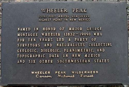 Summit PlaqueSummit plaque on Wheeler Peak, marking New Mexico’s highest point.
Reaching the Summit: Trail Options and Considerations
While the first ascent likely belongs to the Taos Pueblo Indians, the peak is named after Major George M. Wheeler, a US Army surveyor who mapped the region in the late 19th century. Two primary trails lead to Wheeler Peak’s summit:
- Bull-of-the-Woods Trail (Wheeler Peak Trail): A well-maintained, 16-mile roundtrip Class 1 trail, suitable for both day hiking and backpacking.
- Williams Lake Trail: A steeper, 7-mile roundtrip Class 2 trail, culminating in a challenging scree slope for the final 1,000 feet.
Both trails offer breathtaking views and potential encounters with bighorn sheep. Choosing the right trail depends on your experience level and desired challenge.
Planning Your Wheeler Peak Adventure: Getting There
To reach the trailheads from Taos, New Mexico, follow these directions:
- Drive north on NM 522 for four miles.
- Turn right (east) onto NM 150 at the first traffic light.
- Continue for 15 miles to the Taos Ski Valley.
Bull-of-the-Woods Trailhead: Stay left at the ski resort fork, proceed to the upper parking lot, and look for the “RVs Only” gravel lot (not applicable in summer). Trailhead signs are prominently displayed.
Williams Lake Trailhead: Follow signs to “The Bavarian” or “Williams Lake Trail”. Park in the large hiker’s lot on the right, then follow the pedestrian road past The Bavarian and Phoenix Grill (ski season only) to the clearly marked trailhead.
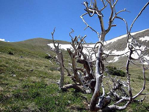 La Cal BasinLa Cal Basin, a potential camping spot along the Bull-of-the-Woods Trail to Wheeler Peak.
Regulations and Permits for Wheeler Peak
Wheeler Peak resides within the Wheeler Peak Wilderness of the Carson National Forest. Fortunately, no fees or permits are required for hiking, climbing, or camping. However, a 14-day camping limit applies within the Carson National Forest. Wilderness regulations prohibit mountain bikes, ATVs, and other motorized vehicles. Remember to respect private property along the initial sections of both trails. Camping is not allowed at Williams Lake.
Best Climbing Season for Wheeler Peak
The ideal climbing season for Wheeler Peak spans from late May through November. Winter storms can linger into May, while June is typically dry. July and August bring monsoon season, with frequent afternoon thunderstorms. September to early November offers another dry window with cooler temperatures and clear skies. Be prepared for unpredictable weather regardless of the season.
Mountain Conditions and Safety Precautions
Wheeler Peak’s alpine environment presents challenges like loose scree slopes and unpredictable weather. Check the National Weather Service forecast before your climb. Fire danger varies daily; consult the ranger station or New Mexico Fire Information Site for updates. Treeline sits around 11,000 to 11,600 feet. Williams Lake basin and the west face of Wheeler Peak are avalanche prone in winter. The Taos Ski Valley webcam can provide a glimpse of current conditions at the base.
Camping Near Wheeler Peak
Backcountry camping is permitted within the wilderness area, except within 100 yards of Williams Lake. La Cal Basin offers a suitable camping location along the Bull-of-the-Woods Trail. Several Forest Service Campgrounds with amenities are available on NM 150 before reaching Taos Ski Valley.
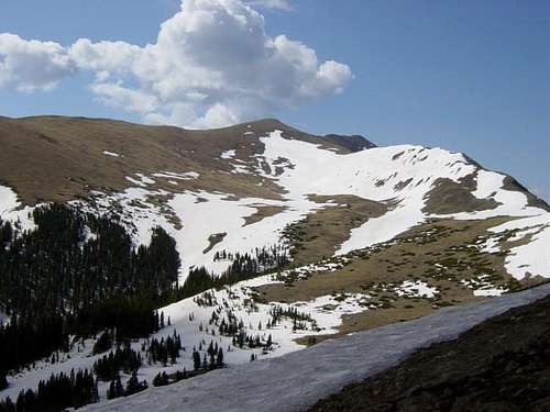 La Cal Basin to the SE as…La Cal Basin, a popular camping area for hikers tackling Wheeler Peak.
Essential Maps for Wheeler Peak
Recommended maps include:
- Carson National Forest (Forest Service)
- Latir Peak/Wheeler Peak Wilderness (Forest Service)
- USGS 1/24 quad Wheeler Peak
- USGS 1/24 quad Eagle Nest
You can order Forest Service maps online.
Conclusion: Planning for a Successful Wheeler Peak Climb
Wheeler Peak offers a memorable high-altitude adventure in the heart of New Mexico. With careful planning, awareness of weather conditions, and respect for the wilderness environment, you can enjoy a safe and rewarding experience conquering the state’s highest point. Remember to check weather forecasts, fire conditions, and avalanche reports before embarking on your journey.