Mexico, a vibrant land brimming with culture and history, is a captivating destination for LGBTQ+ travelers. Mexico can be divided into nine major diverse physiographic regions, each offering unique experiences and landscapes. With gaymexico.net, discover LGBTQ+-friendly hotspots, cultural insights, and essential travel tips for an unforgettable adventure.
1. What Are The Major Physiographic Regions Of Mexico?
Mexico is divided into nine major physiographic regions, each with distinct geographical features: Baja California, the Pacific Coastal Lowlands, the Mexican Plateau, the Sierra Madre Oriental, the Sierra Madre Occidental, the Cordillera Neo-Volcánica, the Gulf Coastal Plain, the Southern Highlands, and the Yucatán Peninsula. These regions contribute to Mexico’s diverse landscapes, climates, and cultural identities.
2. What Is Unique About The Baja California Region?
Baja California is an isolated, arid peninsula in northwestern Mexico, stretching between the Pacific Ocean and the Gulf of California. The peninsula is characterized by its dramatic desert landscapes, rugged mountains, and stunning coastlines. It’s a haven for outdoor enthusiasts, offering activities like whale watching, surfing, and exploring unique desert ecosystems. The central core of the peninsula is a granitic fault block with peaks of more than 9,000 feet (2,700 metres) above sea level in the Sierra San Pedro Mártir and Sierra de Juárez.
3. Where Are The Pacific Coastal Lowlands Located?
The Pacific Coastal Lowlands extend along Mexico’s western coast, from Mexicali to Tepic, traversing the states of Sonora, Sinaloa, and Nayarit. Bounded by the Sierra Madre Occidental, the lowlands feature coastal terraces, mesas, and riverine deltas. The northern section, dominated by the Sonoran Desert, contrasts with the irrigated farmlands that have transformed parts of the region into productive agricultural areas.
4. What Defines The Mexican Plateau?
The Mexican Plateau, the largest and most populated region, is an inland area flanked by the Sierra Madre Occidental and Sierra Madre Oriental. It comprises the Mesa del Norte (Northern Plateau) and the Mesa Central. The Mesa del Norte begins near the U.S. border and stretches southward, while the Mesa Central, located further south, is known for its fertile basins and higher population density. The plateau’s elevation increases from north to south, with the Mesa Central rising to 7,000–9,000 feet (2,100–2,700 metres) near Mexico City.
5. What Are The Key Features Of The Sierra Madre Occidental?
The Sierra Madre Occidental forms the western border of the Mexican Plateau and is characterized by its volcanic landscape and deep gorges. The region’s average elevation ranges from 8,000–9,000 feet (2,400–2,700 metres). Westward-flowing streams have carved out spectacular canyons, including the famous Copper Canyon (Barranca del Cobre) in Chihuahua state, offering breathtaking views and opportunities for hiking and exploration.
Copper Canyon (Barranca del Cobre) in the Sierra Madre Occidental, in Chihuahua state, Mexico. The Sierra Madre Occidental is also known for its rich mining history and indigenous communities.
6. What Characterizes The Sierra Madre Oriental?
The Sierra Madre Oriental, a range of folded mountains composed of shales and limestones, runs along the eastern side of the Mexican Plateau. Often considered an extension of the Rocky Mountains, it stretches from north to south before merging with the Cordillera Neo-Volcánica. With average elevations similar to the Sierra Madre Occidental, some peaks rise above 12,000 feet (3,650 metres). The mountains are rich in mineral deposits, including copper, lead, and zinc.
7. What Makes The Cordillera Neo-Volcánica Unique?
The Cordillera Neo-Volcánica, also known as the Neo-Volcanic Axis, is a geologically active mountain range that connects the Sierra Madre Occidental and Sierra Madre Oriental. This region is famous for its stunning volcanic peaks, including Citlaltépetl, Popocatépetl, and Iztaccíhuatl. The Cordillera Neo-Volcánica crosses Mexico from west to east, forming a dramatic backdrop for several states and offering fertile soils ideal for agriculture.
8. Where Is The Gulf Coastal Plain Located?
The Gulf Coastal Plain extends along the Gulf of Mexico, stretching from Tamaulipas to the Yucatán Peninsula. This region is characterized by its flat terrain, lagoons, and swampy areas. The plain widens in the northern portion near the U.S. border and narrows towards the south. The Gulf Coastal Plain is vital for agriculture and oil production, contributing significantly to Mexico’s economy.
9. What Are The Defining Features Of The Southern Highlands?
The Southern Highlands comprise a series of dissected mountain ranges and plateaus, including the Sierra Madre del Sur, Mesa del Sur, and the Chiapas Highlands. The Sierra Madre del Sur features crystalline mountains that often reach the sea, creating a rugged coastal margin known as the Mexican Riviera. The inland basins provide a challenging environment for agriculture, while the Oaxaca Valley stands out as the most densely settled area, with a predominantly indigenous population.
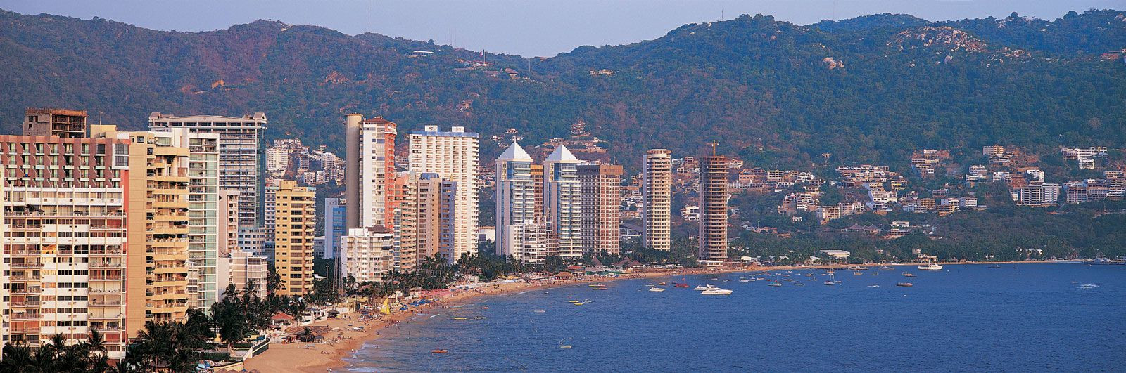 Acapulco, Mexico
Panoramic view of the coastal resort of Acapulco, Mexico. Acapulco is a popular destination within the Southern Highlands, offering beautiful beaches and a vibrant nightlife.
10. What Is Distinctive About The Yucatán Peninsula?
The Yucatán Peninsula, northeast of the Tabasco Plain, is known for its flat limestone terrain, subterranean caverns, and cenotes (sinkholes). The peninsula rarely exceeds 500 feet (150 metres) in elevation and lacks surface drainage due to its porous limestone bedrock. The Yucatán Peninsula is a popular tourist destination, famous for its Mayan ruins, beautiful beaches, and vibrant cultural heritage.
1. Baja California: A Desert Oasis
Baja California, an isolated peninsula in northwestern Mexico, offers a unique blend of desert landscapes and coastal beauty. This region, stretching between the Pacific Ocean and the Gulf of California, is divided between the states of Baja California and Baja California Sur.
1.1 Geography and Topography
The peninsula is nearly 800 miles (1,300 km) long but seldom more than 100 miles (160 km) wide. The central core features a granitic fault block with peaks exceeding 9,000 feet (2,700 metres) above sea level in the Sierra San Pedro Mártir and Sierra de Juárez. The western side slopes gently, contrasting with the steep eastern escarpment, making access from the Gulf of California challenging.
1.2 Climate and Environment
Baja California’s climate is extremely arid, with the Sonoran Desert extending onto the peninsula along the northern end of the Gulf. The region’s unique desert ecosystem supports a variety of plant and animal life adapted to the harsh conditions.
1.3 Tourist Attractions and Activities
Baja California is a haven for outdoor enthusiasts. Popular activities include:
- Whale watching in the Pacific Ocean
- Surfing along the coast
- Exploring the desert landscapes
- Visiting the historic towns of La Paz and Ensenada
2. Pacific Coastal Lowlands: Fertile Plains
The Pacific Coastal Lowlands extend along Mexico’s western coast, from Mexicali to Tepic, spanning approximately 900 miles (1,450 km). This region faces the Gulf of California and traverses the states of Sonora, Sinaloa, and Nayarit.
2.1 Geography and Topography
Bounded by the Sierra Madre Occidental, the lowlands consist of coastal terraces, mesas, and small basins interspersed with riverine deltas and coastal strips.
2.2 Climate and Agriculture
Although the Sonoran Desert dominates the northern section, irrigation has transformed parts of the lowlands into highly productive farmland. The region’s agricultural output includes crops like:
- Vegetables
- Fruits
- Grains
2.3 Key Cities and Attractions
Notable cities and attractions in the Pacific Coastal Lowlands include:
- Mazatlán: A popular beach resort city
- Culiacán: An agricultural and commercial center
- Hermosillo: The capital of Sonora state
3. Mexican Plateau: The Heart of Mexico
The Mexican Plateau, the largest and most densely populated region, is an inland area flanked by the Sierra Madre Occidental and Sierra Madre Oriental.
3.1 Geography and Divisions
The plateau consists of the Mesa del Norte (Northern Plateau) and the Mesa Central (Mesa de Anáhuac). The Mesa del Norte begins near the U.S. border, covering parts of Chihuahua, Coahuila, Durango, Zacatecas, Jalisco, and Aguascalientes. The Mesa Central stretches from San Luis Potosí to just south of Mexico City.
3.2 Topography and Climate
The plateau tilts gently upward from north to south. The Mesa del Norte is about 4,000 feet (1,200 metres) above sea level at its northern end. Relatively flat intermontane basins and bolsones (ephemeral interior drainage basins) are interrupted by mountainous outcrops. The Chihuahuan Desert covers a significant portion of the northern plateau.
3.3 Mesa Central
The Mesa Central covers large parts of Michoacán, Guanajuato, Querétaro, Hidalgo, México states, and the Federal District (Mexico City). Its southern end rises 7,000–9,000 feet (2,100–2,700 metres) in the vicinity of Mexico City.
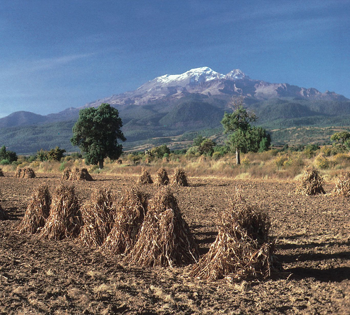 Iztaccíhuatl volcano, Puebla state, Mexico
The snowcapped peak of the volcano Iztaccíhuatl overlooking harvested corn in the agricultural region of Puebla state in the Mesa Central of Mexico. The Mesa Central is moister and generally flatter than the Mesa del Norte. It is divided into fairly level intermontane basins separated by eroded volcanic peaks. The Bajío (Basin of Guanajuato) is the traditional breadbasket of the country.
3.4 Historical Significance
Many basins were once sites of major lakes that were drained to facilitate European and mestizo settlement. Around Mexico City, the weak, structurally unstable soils have caused colonial-era buildings to shift on their foundations.
4. Sierra Madre Occidental: Western Border
The Sierra Madre Occidental forms the western border of the Mexican Plateau. This largely volcanic region averages 8,000–9,000 feet (2,400–2,700 metres) in elevation and extends roughly 700 miles (1,100 km) from north to south.
4.1 Topography and Gorges
Westward-flowing streams have deeply incised the range, forming a series of gorges, or barrancas. The most spectacular is Copper Canyon (Barranca del Cobre) in southwestern Chihuahua state.
4.2 Flora and Fauna
The Sierra Madre Occidental is home to diverse plant and animal life, including pine-oak forests, unique bird species, and mammals like the Mexican wolf and black bear.
4.3 Economic Activities
Mining and forestry are major economic activities in the Sierra Madre Occidental. The region is rich in mineral resources, including gold, silver, and copper.
5. Sierra Madre Oriental: Eastern Border
The Sierra Madre Oriental is situated on the eastern side of the Mexican Plateau. This range of folded mountains, formed of shales and limestones, is often considered an extension of the Rocky Mountains.
5.1 Geography and Extension
The range runs roughly 700 miles (1,100 km) from north to south before merging with the Cordillera Neo-Volcánica. Its average elevations are similar to those of the Sierra Madre Occidental, but some peaks rise above 12,000 feet (3,650 metres).
5.2 Mineral Deposits
The mountains contain major deposits of copper, lead, and zinc. These resources have supported mining activities in the region for centuries.
5.3 Cities and Cultural Heritage
Major cities in or near the Sierra Madre Oriental include Monterrey, Saltillo, and Ciudad Victoria. The region is known for its colonial architecture, cultural traditions, and proximity to natural attractions like national parks and reserves.
6. Cordillera Neo-Volcánica: Volcanic Axis
The Cordillera Neo-Volcánica, also called the Neo-Volcanic Axis or Trans-Volcanic Axis, is a geologically active mountain range that links the Sierra Madre Occidental with the Sierra Madre Oriental.
6.1 Geographical Span
As it crosses Mexico from Cape Corrientes on the west coast to Xalapa and Veracruz on the eastern coast, it forms a mountainous backdrop to the states of Jalisco, Michoacán, Guerrero, México, Morelos, and Puebla, as well as the Federal District.
6.2 Volcanic Peaks
This volcanic range includes spectacular peaks such as Citlaltépetl, Popocatépetl, and Iztaccíhuatl. Parícutin, one of the world’s youngest volcanoes, emerged violently from the fields of Michoacán between 1943 and 1952.
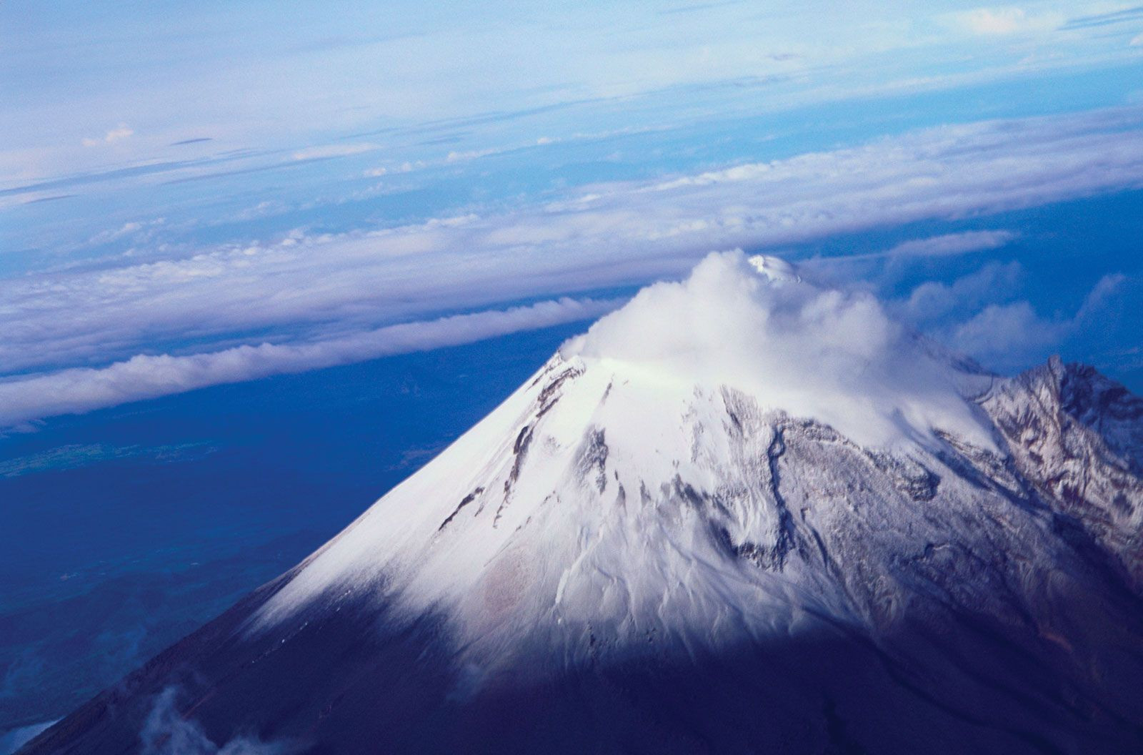 Citlaltépetl, Veracruz state, Mexico
Citlaltépetl (Orizaba Peak), the highest point in Mexico, located in western Veracruz state. The Cordillera Neo-Volcánica is vital for agriculture, with fertile volcanic soils supporting a variety of crops.
6.3 Natural Resources
The region is rich in silver, lead, zinc, copper, and tin deposits. These mineral resources have been historically significant for Mexico’s economy.
7. Gulf Coastal Plain: Eastern Lowlands
The Gulf Coastal Plain, much wider than its Pacific coast counterpart, extends some 900 miles (1,450 km) along the Gulf of Mexico from Tamaulipas state (on the Texas border) through Veracruz and Tabasco states to the Yucatán Peninsula.
7.1 Geographic Features
It includes the Tabasco Plain in its southeastern section. The triangular northern portion of the plain, characterized by lagoons and low-lying swampy areas, reaches a width of more than 100 miles (160 km) near the U.S. border but tapers toward the south.
7.2 Topographical Breaks
North of the port of Tampico, an outlier of the Sierra Madre Oriental reaches the sea and interrupts the continuity of the Gulf Coastal Plain. South from there, the plain is narrow and irregular, widening at the northern end of the Isthmus of Tehuantepec.
7.3 Economic Importance
The Gulf Coastal Plain is vital for agriculture, livestock raising, and oil production. The region’s resources have played a crucial role in Mexico’s economic development.
8. Southern Highlands: Mountainous South
The Southern Highlands are a series of highly dissected mountain ranges and plateaus, including the Sierra Madre del Sur, Mesa del Sur, and the Chiapas Highlands.
8.1 Sierra Madre del Sur
On their southwestern side, approximately from Puerto Vallarta to the Gulf of Tehuantepec, are a series of relatively low ranges known collectively as the Sierra Madre del Sur. The crystalline mountains, which achieve elevations of 7,000–8,000 feet (2,100–2,400 metres), often reach the sea to create a rugged coastal margin, part of which is known as the Mexican Riviera.
8.2 Tourist Destinations
Several coastal sites, such as Ixtapa-Zihuatanejo, Acapulco, and Puerto Escondido, have become alluring tourist destinations. However, the less-hospitable inland basins provide a difficult environment for traditional peasant farmers.
8.3 Mesa del Sur
Farther northeast is the Mesa del Sur, with numerous stream-eroded ridges and small isolated valleys some 4,000–5,000 feet (1,200–1,500 metres) above sea level. The picturesque Oaxaca Valley is the largest and most densely settled of these, with a predominantly indigenous population. It is one of the poorest areas of Mexico.
8.4 Isthmus of Tehuantepec
Bisecting the Southern Highlands is the Isthmus of Tehuantepec, a low-lying, narrow constriction of land that reaches an elevation of less than 900 feet (275 metres). Its hilly central area descends to narrow coastal plains on the south and to the Tabasco Plain on the north.
8.5 Chiapas Highlands
The Chiapas Highlands are an extension of the mountain ranges of Central America. Within the highlands, the low, crystalline Sierra de Soconusco range lies along the Pacific coast. To the northwest and paralleling the coast is the Grijalva River valley. A group of highly dissected, folded, and faulted mountains is located between the valley and the Tabasco Plain, a southeastern extension of the Gulf Coastal Plain. Among the active volcanic peaks of the region is El Chichón, which destroyed several villages in 1982.
9. Yucatán Peninsula: Limestone Landscape
The Yucatán Peninsula lies to the northeast of the Tabasco Plain and extends northward, forming a divider between the Gulf of Mexico and the Caribbean Sea.
9.1 Terrain and Drainage
The peninsula’s limestone (karst) terrain is generally pockmarked and uneven but seldom exceeds 500 feet (150 metres) in elevation. There is little surface drainage, and subterranean erosion has produced caverns and sinkholes (cenotes), the latter being formed when cavern roofs collapse.
9.2 Islands and Resorts
The islands of Cozumel and Mujeres lie off the peninsula’s northeastern tip, near the resort boomtown of Cancún. These islands offer beautiful beaches, coral reefs, and opportunities for snorkeling and diving.
9.3 Cultural Significance
The Yucatán Peninsula is home to numerous Mayan ruins, including Chichen Itza and Tulum, which attract tourists from around the world. The region’s rich cultural heritage and natural beauty make it a popular destination for LGBTQ+ travelers seeking adventure and relaxation.
Mexico: A Tapestry of Regions
Mexico’s diverse physiographic regions offer a wide array of experiences, from the arid deserts of Baja California to the lush rainforests of the Southern Highlands. Each region contributes to the country’s rich cultural tapestry, making Mexico a destination that appeals to every traveler. Whether you’re exploring ancient ruins, relaxing on pristine beaches, or immersing yourself in vibrant city life, Mexico has something to offer everyone.
LGBTQ+ Travel in Mexico: A Welcoming Destination
Mexico has become increasingly welcoming to LGBTQ+ travelers, with many cities and regions embracing diversity and inclusivity. According to research from the UCLA Williams Institute, in July 2023, LGBTQ+ tourism contributed significantly to Mexico’s economy, providing numerous opportunities for community engagement and cultural exchange. Some of the most popular LGBTQ+-friendly destinations in Mexico include:
- Puerto Vallarta: Known as the “San Francisco of Mexico,” Puerto Vallarta boasts a vibrant gay scene with numerous bars, clubs, and hotels catering to the LGBTQ+ community.
- Mexico City: The capital city offers a thriving LGBTQ+ culture with diverse neighborhoods, cultural events, and a welcoming atmosphere.
- Cancún: While primarily known as a tourist hotspot, Cancún has a growing LGBTQ+ scene with inclusive resorts and nightlife options.
For LGBTQ+ travelers, it’s essential to stay informed about local laws and customs to ensure a safe and enjoyable trip. Resources like Human Rights Watch provide valuable insights into the legal and social landscape for LGBTQ+ individuals in Mexico.
Gaymexico.net: Your Ultimate Guide to LGBTQ+ Mexico
For comprehensive and up-to-date information on LGBTQ+ travel in Mexico, gaymexico.net is your go-to resource. Our website offers:
- Detailed travel guides to LGBTQ+-friendly cities and regions
- Listings of gay bars, clubs, hotels, and events
- News and information on LGBTQ+ rights and issues in Mexico
- Community forums to connect with other LGBTQ+ travelers and locals
At gaymexico.net, we believe that travel should be an enriching and inclusive experience for everyone. That’s why we’re committed to providing the resources and support you need to explore Mexico with confidence and pride.
Planning Your Trip to Mexico
When planning your trip to Mexico, consider the following tips to ensure a safe and enjoyable experience:
- Research LGBTQ+-friendly destinations: Look for cities and regions known for their inclusive atmosphere and vibrant LGBTQ+ communities.
- Book accommodations at LGBTQ+-friendly hotels or resorts: These establishments often cater specifically to LGBTQ+ travelers and provide a welcoming environment.
- Learn basic Spanish phrases: Knowing a few basic phrases can help you navigate local interactions and show respect for the local culture.
- Be aware of local laws and customs: Stay informed about LGBTQ+ rights and social norms in Mexico to avoid misunderstandings or uncomfortable situations.
- Connect with local LGBTQ+ organizations: These groups can provide valuable insights, resources, and support during your trip.
By taking these precautions and staying informed, you can ensure a memorable and affirming experience in Mexico.
Connect With Us
Have questions or need more information? Contact us at:
Address: 3255 Wilshire Blvd, Los Angeles, CA 90010, United States
Phone: +1 (213) 380-2177
Website: gaymexico.net
Explore Mexico’s diverse regions and vibrant LGBTQ+ culture with gaymexico.net. Discover your next adventure today!
Frequently Asked Questions (FAQ)
1. What is the most LGBTQ+-friendly region in Mexico?
Puerto Vallarta is widely known as one of the most LGBTQ+-friendly regions in Mexico, boasting a vibrant gay scene with numerous bars, clubs, and hotels catering to the community.
2. Is Mexico City safe for LGBTQ+ travelers?
Yes, Mexico City is generally safe and welcoming for LGBTQ+ travelers, offering a thriving LGBTQ+ culture with diverse neighborhoods, cultural events, and a progressive atmosphere.
3. What are the key geographical features of the Yucatán Peninsula?
The Yucatán Peninsula is characterized by its flat limestone terrain, subterranean caverns, and cenotes (sinkholes), with little surface drainage due to its porous bedrock.
4. What is the significance of the Cordillera Neo-Volcánica?
The Cordillera Neo-Volcánica is a geologically active mountain range known for its stunning volcanic peaks, fertile soils, and rich mineral deposits, connecting the Sierra Madre Occidental and Sierra Madre Oriental.
5. How has irrigation impacted the Pacific Coastal Lowlands?
Irrigation has transformed parts of the Pacific Coastal Lowlands into highly productive farmland, supporting a variety of crops despite the dominance of the Sonoran Desert in the northern section.
6. What cultural attractions can be found in the Southern Highlands?
The Southern Highlands feature picturesque valleys, indigenous communities, and historic sites, including the Oaxaca Valley, which is known for its rich cultural heritage and traditional crafts.
7. What economic activities are prominent in the Sierra Madre Occidental?
Mining and forestry are major economic activities in the Sierra Madre Occidental, thanks to its rich mineral resources and diverse plant and animal life.
8. How does the Gulf Coastal Plain contribute to Mexico’s economy?
The Gulf Coastal Plain is vital for agriculture, livestock raising, and oil production, with its resources playing a crucial role in Mexico’s economic development.
9. What geological processes shaped the landscape of Baja California?
Baja California’s landscape was shaped by granitic fault blocks, creating rugged mountains and dramatic desert landscapes between the Pacific Ocean and the Gulf of California.
10. How can gaymexico.net help LGBTQ+ travelers planning a trip to Mexico?
gaymexico.net provides detailed travel guides, listings of LGBTQ+-friendly establishments, news on LGBTQ+ rights, and community forums to help travelers explore Mexico with confidence and pride.