What Is The Country Of Mexico known for? Mexico, a vibrant and diverse nation, is celebrated for its rich cultural heritage, stunning landscapes, and warm hospitality, making it a premier destination for LGBTQ+ travelers seeking an unforgettable experience. At gaymexico.net, we provide comprehensive and up-to-date information to help you discover the best of Mexico, from its inclusive destinations to its exciting events. Dive into the beauty and allure of this amazing country with us, exploring its cultural landmarks, delicious cuisine, and welcoming atmosphere.
1. What Defines the Country of Mexico?
Mexico, officially the United Mexican States, is a country in the southern portion of North America. It is defined by its vibrant culture, diverse landscapes, and rich history. Mexico is bordered by the United States to the north; the Pacific Ocean to the west; Guatemala, Belize, and the Caribbean Sea to the southeast; and the Gulf of Mexico to the east. This unique geography and cultural mix make Mexico a fascinating country for LGBTQ+ travelers.
Mexico is known for its ancient ruins, such as Teotihuacan and Chichen Itza, which offer a glimpse into the advanced civilizations of the past. According to the National Institute of Anthropology and History (INAH), these sites attract millions of visitors each year. The country’s colonial architecture, particularly in cities like San Miguel de Allende and Oaxaca, showcases its Spanish heritage. These cities, recognized as UNESCO World Heritage sites, provide a picturesque backdrop for exploring Mexico’s rich history.
The country is also famous for its diverse ecosystems, ranging from arid deserts in the north to lush rainforests in the south. According to the National Commission for the Knowledge and Use of Biodiversity (CONABIO), Mexico is one of the world’s megadiverse countries, hosting a significant portion of the planet’s biodiversity. This natural diversity is a major draw for ecotourists and nature enthusiasts.
Mexican cuisine is another defining aspect of the country. Dishes like tacos, enchiladas, and mole are staples, and regional variations offer a wide array of flavors. The country’s culinary traditions, recognized by UNESCO, are a testament to its cultural richness. For LGBTQ+ travelers, exploring Mexico’s culinary scene is an opportunity to connect with local culture and enjoy the vibrant flavors of the country.
2. What Are the Key Geographical Regions of Mexico?
Mexico’s diverse geography is divided into nine major physiographic regions, each with unique characteristics. These regions include Baja California, the Pacific Coastal Lowlands, the Mexican Plateau, the Sierra Madre Oriental, the Sierra Madre Occidental, the Cordillera Neo-Volcánica, the Gulf Coastal Plain, the Southern Highlands, and the Yucatán Peninsula.
-
Baja California: This peninsula is an arid strip of land between the Pacific Ocean and the Gulf of California. According to the National Autonomous University of Mexico (UNAM), its unique desert landscape and marine ecosystems make it a biodiversity hotspot.
-
Pacific Coastal Lowlands: Stretching from Mexicali to Tepic, these lowlands are characterized by coastal terraces, mesas, and river deltas. The region is known for its agricultural productivity, especially in areas where irrigation is used.
-
Mexican Plateau: The largest and most densely populated region, flanked by the Sierra Madre Occidental and Oriental, consisting of the Mesa del Norte and the Mesa Central.
-
Sierra Madre Occidental: This volcanic mountain range forms the western border of the Mexican Plateau, known for its deep gorges and the Copper Canyon.
-
Sierra Madre Oriental: A range of folded mountains on the eastern side of the Mexican Plateau, rich in mineral deposits like copper, lead, and zinc.
-
Cordillera Neo-Volcánica: A geologically active mountain range linking the Sierra Madre Occidental and Oriental, featuring iconic volcanoes like Citlaltépetl and Popocatépetl.
-
Gulf Coastal Plain: Extends along the Gulf of Mexico, characterized by lagoons and swampy areas. The northern portion is wider, while the southern part narrows towards the Isthmus of Tehuantepec.
-
Southern Highlands: A series of dissected mountain ranges and plateaus, including the Sierra Madre del Sur and the Chiapas Highlands, known for rugged coastlines and inland basins.
-
Yucatán Peninsula: Lies northeast of the Tabasco Plain, featuring a limestone terrain with underground rivers and sinkholes (cenotes).
These diverse regions offer a wide range of experiences for LGBTQ+ travelers, from exploring the beaches of Baja California to hiking in the Sierra Madre mountains.
3. What Role Does the Mexican Plateau Play in Mexico’s Geography?
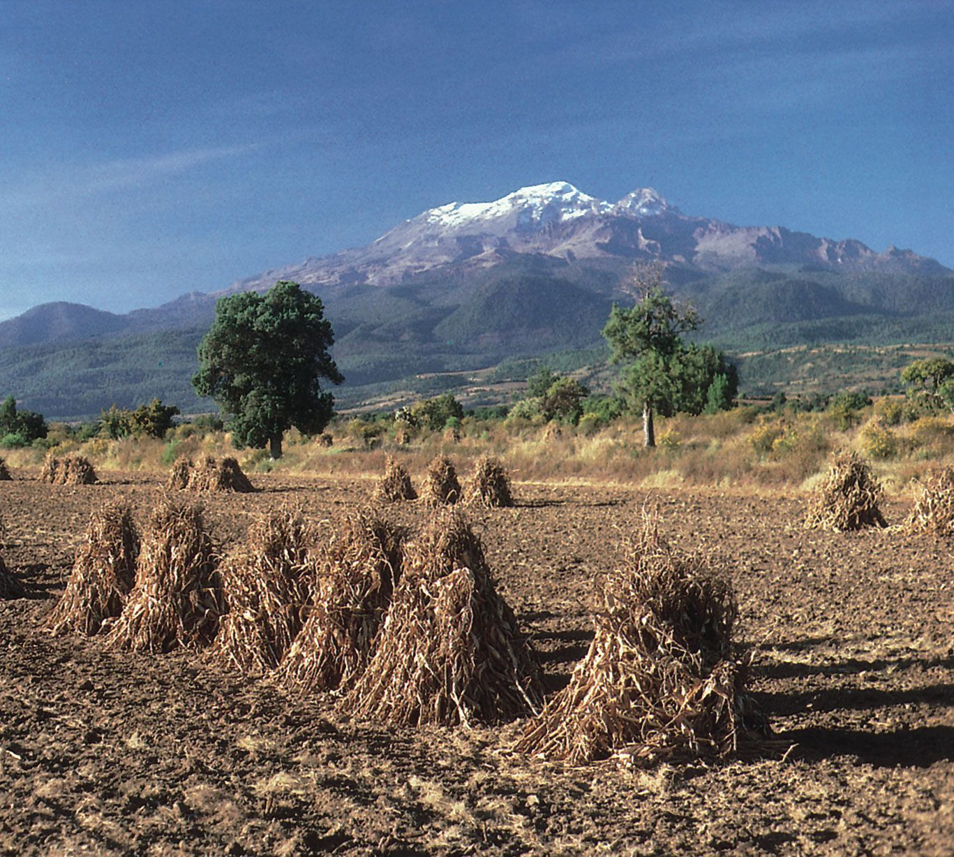 View of Iztaccíhuatl volcano overlooking a harvested corn field
The Mexican Plateau is the largest and most densely populated region in Mexico, playing a central role in the country’s geography and economy. The snowcapped peak of the volcano Iztaccíhuatl overlooking harvested corn in the agricultural region of Puebla state in the Mesa Central of Mexico. Flanked by the Sierra Madre Occidental and Sierra Madre Oriental, the plateau consists of the Mesa del Norte (Northern Plateau) and the Mesa Central (Central Plateau). This area significantly influences Mexico’s climate, agriculture, and population distribution.
The Mesa del Norte begins near the U.S. border and extends through several states, including Chihuahua, Coahuila, and Durango. The Chihuahuan Desert covers a large section of this plateau, making it one of the driest regions in North America. Despite the arid conditions, the Mesa del Norte is important for mining and ranching activities.
The Mesa Central, located south of the Mesa del Norte, is more heavily populated and agriculturally productive. This region includes major cities like Guadalajara and Mexico City. According to the Mexican Institute of Geography and Statistics (INEGI), the Mesa Central benefits from a more temperate climate and fertile soils, supporting a wide range of agricultural activities. The Bajío region, within the Mesa Central, is known as the traditional breadbasket of the country.
The Mexican Plateau’s elevation, ranging from 4,000 to 9,000 feet above sea level, creates a unique climate that is cooler and drier than the coastal regions. This has made it a preferred area for human settlement and agriculture throughout Mexico’s history.
4. How Do the Sierra Madre Mountain Ranges Impact Mexico’s Landscape?
The Sierra Madre Occidental and Sierra Madre Oriental are two major mountain ranges that significantly impact Mexico’s landscape, climate, and biodiversity. The Sierra Madre Occidental, a largely volcanic range, forms the western border of the Mexican Plateau. With an average elevation of 8,000–9,000 feet, it extends approximately 700 miles from north to south. The range is deeply incised by westward-flowing streams, creating a series of dramatic gorges, including the Copper Canyon (Barranca del Cobre) in Chihuahua state.
The Sierra Madre Oriental, composed of folded mountains made of shales and limestones, is situated on the eastern side of the Mexican Plateau. Often considered an extension of the Rocky Mountains, it runs about 700 miles from north to south, merging with the Cordillera Neo-Volcánica. The average elevations are similar to the Sierra Madre Occidental, with some peaks rising above 12,000 feet.
These mountain ranges play a crucial role in Mexico’s climate. They act as barriers that influence precipitation patterns, creating rain shadows and contributing to the diverse climates found across the country. The mountains also provide habitats for a wide variety of plant and animal species, contributing to Mexico’s status as a megadiverse country.
For LGBTQ+ travelers, the Sierra Madre ranges offer opportunities for hiking, ecotourism, and exploring the natural beauty of Mexico.
5. What Is the Significance of the Cordillera Neo-Volcánica?
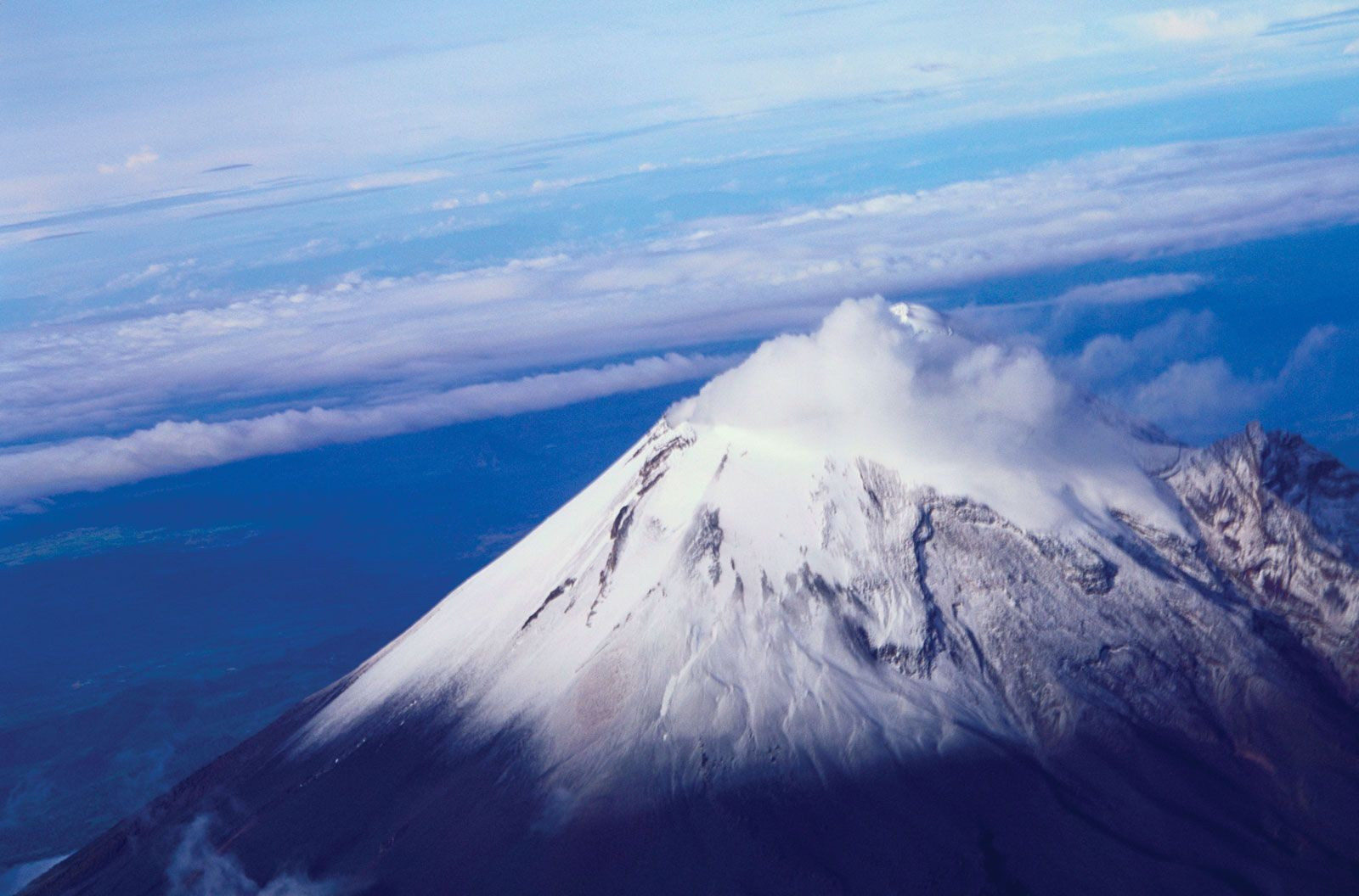 View of Citlaltépetl, Veracruz state, Mexico
The Cordillera Neo-Volcánica, also known as the Neo-Volcanic Axis or Trans-Volcanic Axis, is a geologically active mountain range that is vital to Mexico’s landscape and natural resources. Citlaltépetl (Orizaba Peak), the highest point in Mexico, located in western Veracruz state. It links the Sierra Madre Occidental with the Sierra Madre Oriental at the southern edge of the Mesa Central. This range crosses Mexico from Cape Corrientes on the west coast to Xalapa and Veracruz on the eastern coast, forming a mountainous backdrop for several states, including Jalisco, Michoacán, and Puebla.
The Cordillera Neo-Volcánica is characterized by its volcanic activity, featuring numerous cinder cones and stratovolcanoes. This region is home to some of Mexico’s highest peaks, including Citlaltépetl (Pico de Orizaba), Popocatépetl, and Iztaccíhuatl. According to the National Center for Disaster Prevention (CENAPRED), Popocatépetl remains an active volcano, requiring constant monitoring.
The volcanic activity in the Cordillera Neo-Volcánica has enriched the surrounding soils, making the region highly fertile and suitable for agriculture. The area is also rich in mineral deposits, including silver, lead, zinc, copper, and tin. One of the world’s youngest volcanoes, Parícutin, emerged from the fields of Michoacán between 1943 and 1952, showcasing the dynamic geological processes at play in this region.
For LGBTQ+ travelers interested in geology and natural landscapes, the Cordillera Neo-Volcánica offers unique opportunities to explore volcanic formations, hike to high-altitude peaks, and witness the ongoing geological activity that shapes Mexico.
6. How Do the Gulf and Pacific Coastal Plains Differ?
The Gulf Coastal Plain and the Pacific Coastal Lowlands are two distinct geographic regions in Mexico, each with unique characteristics and economic significance. The Gulf Coastal Plain extends approximately 900 miles along the Gulf of Mexico, from Tamaulipas to the Yucatán Peninsula. This plain is much wider than its Pacific coast counterpart, characterized by lagoons, low-lying swampy areas, and the Tabasco Plain in its southeastern section.
The Pacific Coastal Lowlands, on the other hand, stretch about 900 miles from Mexicali to Tepic, facing the Gulf of California. These lowlands are narrower and bounded by the steep-sided Sierra Madre Occidental. They consist of coastal terraces, mesas, and small basins interspersed with riverine deltas and restricted coastal strips.
One key difference is their climate and vegetation. The Gulf Coastal Plain generally receives more rainfall, supporting a more lush and tropical environment compared to the arid and desert-like conditions of the northern Pacific Coastal Lowlands. According to the National Water Commission (CONAGUA), the Gulf region’s higher precipitation levels contribute to its agricultural productivity.
Economically, both regions are important. The Gulf Coastal Plain is rich in petroleum resources, contributing significantly to Mexico’s oil industry. The Pacific Coastal Lowlands, particularly in states like Sinaloa and Sonora, have been transformed into highly productive farmland through irrigation.
7. What Are the Key Features of the Southern Highlands?
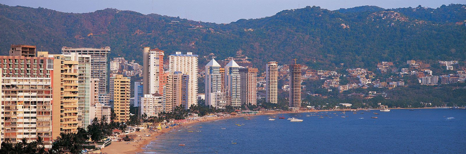 Panoramic view of Acapulco, Mexico
The Southern Highlands of Mexico are a complex and diverse region characterized by a series of dissected mountain ranges and plateaus. Panoramic view of the coastal resort of Acapulco, Mexico. This area includes the Sierra Madre del Sur, Mesa del Sur, and the Chiapas Highlands (Sierra Madre de Chiapas). The region stretches approximately from Puerto Vallarta to the Gulf of Tehuantepec.
The Sierra Madre del Sur features crystalline mountains that often reach the sea, creating a rugged coastal margin known as the Mexican Riviera. Coastal sites like Acapulco and Puerto Escondido have become popular tourist destinations. The Mesa del Sur consists of stream-eroded ridges and small isolated valleys, with the Oaxaca Valley being the largest and most densely settled.
The Chiapas Highlands are an extension of the mountain ranges of Central America. This area includes the Sierra de Soconusco along the Pacific coast and the Grijalva River valley. According to the Secretariat of Environment and Natural Resources (SEMARNAT), the Chiapas Highlands are rich in biodiversity but also face environmental challenges due to deforestation and land use changes.
The Southern Highlands are bisected by the Isthmus of Tehuantepec, a low-lying, narrow constriction of land. This region’s diverse landscapes and cultural heritage offer unique experiences for LGBTQ+ travelers interested in exploring the less-visited parts of Mexico.
8. How Does the Yucatán Peninsula Differ Geologically from Other Regions?
The Yucatán Peninsula, located northeast of the Tabasco Plain, stands out geologically from other regions in Mexico due to its unique limestone (karst) terrain. This peninsula forms a divider between the Gulf of Mexico and the Caribbean Sea. The terrain is generally pockmarked and uneven, with elevations seldom exceeding 500 feet.
Unlike other regions with diverse surface drainage, the Yucatán Peninsula has little surface water. Subterranean erosion has produced extensive caverns and sinkholes, known as cenotes, which are formed when cavern roofs collapse. These cenotes were historically important water sources for the Mayan civilization.
According to the National Institute of Anthropology and History (INAH), the geological features of the Yucatán Peninsula have played a significant role in shaping the region’s cultural and historical development. The lack of surface rivers and the presence of cenotes influenced settlement patterns and agricultural practices of the ancient Maya.
For LGBTQ+ travelers, the Yucatán Peninsula offers a chance to explore these unique geological formations, swim in the crystal-clear waters of the cenotes, and learn about the Mayan civilization that thrived in this region. The islands of Cozumel and Mujeres, located off the peninsula’s northeastern tip near Cancún, provide additional attractions for visitors.
9. What Impact Does Mexico’s Geography Have on Its Climate?
Mexico’s diverse geography significantly influences its climate, creating a wide range of climatic zones across the country. The country’s varied topography, including high mountains, plateaus, and coastal plains, leads to regional climate variations. According to the National Meteorological Service (SMN), Mexico’s climate ranges from arid in the north to tropical in the south.
The Sierra Madre Occidental and Sierra Madre Oriental mountain ranges act as barriers that affect precipitation patterns. The eastern slopes of the Sierra Madre Oriental receive abundant rainfall from the Gulf of Mexico, while the western slopes experience a rain shadow effect, leading to drier conditions.
The Mexican Plateau, with its high elevation, experiences a temperate climate with cooler temperatures and lower humidity compared to the coastal regions. The Cordillera Neo-Volcánica influences regional weather patterns and contributes to fertile soils due to volcanic activity.
The Gulf Coastal Plain has a tropical climate with high humidity and rainfall, while the northern Pacific Coastal Lowlands are arid and desert-like. The Yucatán Peninsula has a tropical climate with a distinct wet and dry season.
These diverse climatic conditions support a wide range of ecosystems and agricultural practices, contributing to Mexico’s biodiversity and economic activities.
10. How Does Mexico’s Geography Influence Its Biodiversity?
Mexico’s geography is a key factor in its remarkable biodiversity. The country’s diverse landscapes, ranging from deserts to rainforests, create a variety of habitats that support a wide range of plant and animal species. According to the National Commission for the Knowledge and Use of Biodiversity (CONABIO), Mexico is considered one of the world’s megadiverse countries.
The mountain ranges, such as the Sierra Madre Occidental and Sierra Madre Oriental, provide diverse microclimates and habitats for numerous endemic species. The Cordillera Neo-Volcánica is home to unique alpine ecosystems and volcanic landscapes that support specialized flora and fauna.
The coastal regions, including the Gulf Coastal Plain and the Pacific Coastal Lowlands, feature diverse marine and terrestrial ecosystems. The Yucatán Peninsula’s unique karst terrain and cenotes provide habitats for specialized aquatic species.
Mexico’s location between North and Central America allows for the mixing of species from both regions, further contributing to its biodiversity. The country’s varied climate zones, influenced by its geography, support a wide range of ecosystems, from arid deserts to tropical rainforests.
The country’s commitment to conservation, as highlighted by organizations like the Mexican Fund for Nature Conservation (FMCN), underscores its dedication to preserving its rich natural heritage. For LGBTQ+ travelers, this biodiversity offers incredible opportunities for ecotourism and nature exploration.
Discover the beauty and diversity of Mexico with gaymexico.net. Whether you’re seeking vibrant cultural experiences, stunning landscapes, or a welcoming LGBTQ+ community, Mexico has something to offer everyone. Visit our website to explore detailed travel guides, find LGBTQ+-friendly accommodations, and connect with local events. Your adventure awaits in Mexico. Address: 3255 Wilshire Blvd, Los Angeles, CA 90010, United States. Phone: +1 (213) 380-2177. Website: gaymexico.net.
FAQ: Exploring the Country of Mexico
1. What is the country of Mexico best known for?
Mexico is best known for its rich cultural heritage, ancient ruins, beautiful beaches, diverse landscapes, and delicious cuisine. It’s also recognized for its vibrant arts scene and warm hospitality.
2. What are the major geographical regions of Mexico?
The major geographical regions include Baja California, the Pacific Coastal Lowlands, the Mexican Plateau, the Sierra Madre Oriental, the Sierra Madre Occidental, the Cordillera Neo-Volcánica, the Gulf Coastal Plain, the Southern Highlands, and the Yucatán Peninsula.
3. How does the Mexican Plateau influence the country’s climate?
The Mexican Plateau’s high elevation leads to a temperate climate with cooler temperatures and lower humidity compared to the coastal regions. It also affects rainfall patterns and supports diverse agricultural activities.
4. What makes the Sierra Madre mountain ranges significant?
The Sierra Madre Occidental and Sierra Madre Oriental are significant for their impact on Mexico’s landscape, climate, and biodiversity. They create rain shadows, provide habitats for diverse species, and offer opportunities for ecotourism.
5. Why is the Cordillera Neo-Volcánica important to Mexico?
The Cordillera Neo-Volcánica is important due to its volcanic activity, fertile soils, and mineral deposits. It is home to some of Mexico’s highest peaks and influences regional weather patterns.
6. How do the Gulf and Pacific Coastal Plains differ from each other?
The Gulf Coastal Plain is wider with more rainfall and tropical vegetation, while the Pacific Coastal Lowlands are narrower, arid, and desert-like in the north. Both are economically important for their respective resources.
7. What are the key attractions in the Southern Highlands?
The Southern Highlands feature rugged coastlines, picturesque valleys, and cultural richness. Popular attractions include Acapulco, Puerto Escondido, and the Oaxaca Valley.
8. What is unique about the Yucatán Peninsula’s geology?
The Yucatán Peninsula’s unique limestone (karst) terrain features underground rivers, cenotes (sinkholes), and a lack of surface drainage, setting it apart from other regions in Mexico.
9. How does Mexico’s geography affect its biodiversity?
Mexico’s diverse geography creates a variety of habitats that support a wide range of plant and animal species, making it one of the world’s megadiverse countries.
10. Where can LGBTQ+ travelers find more information about visiting Mexico?
LGBTQ+ travelers can find comprehensive and up-to-date information on gaymexico.net, including travel guides, LGBTQ+-friendly accommodations, and local events.