Southeastern Mexico faced one of its most severe natural disasters in history when torrential rains caused widespread flooding in the state of Tabasco in late October and early November 2007. The disaster, impacting over a million people, submerged approximately 70 percent of the state, leaving hundreds of thousands trapped and prompting international attention. NASA satellite imagery captured the magnitude of the event, revealing the stark contrast between the region before and during the deluge.
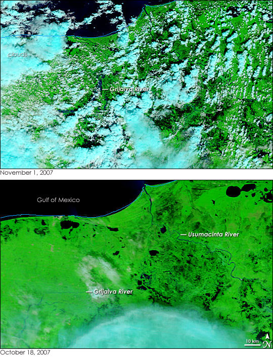 Extensive flooding in southeastern Mexico, particularly Tabasco state, is visible in this NASA satellite image from November 1, 2007. The image, captured by MODIS on the Terra satellite, shows the aftermath of days of torrential rain that submerged much of the region.
Satellite Imagery Reveals Extent of Southeastern Mexico Floods
NASA’s Moderate Resolution Imaging Spectroradiometer (MODIS) aboard the Terra satellite provided crucial visual evidence of the Southeastern Mexico Floods. Comparing images from October 18, 2007, before the heavy rains, and November 1, 2007, the extent of the disaster becomes strikingly clear. The images, processed using infrared and visible light, differentiate land from water, highlighting the dramatic increase in water coverage. Plant-covered land appears bright green, while floodwaters are depicted in dark blue to black, making the inundated areas easily discernible.
Prior to the floods, on October 18, the imagery shows the natural landscape with the Grijalva and Usumacinta Rivers converging, surrounded by darker areas indicating lakes and wetlands. By November 1, the landscape had transformed. While cloud cover obscured some areas, breaks in the clouds revealed a vastly different scene. The wetlands appeared possibly expanded, though cloud shadows made precise differentiation challenging. Most dramatically, the Grijalva River, crucial to the region, swelled to many times its pre-flood width, particularly noticeable in the areas visible through breaks in the cloud cover.
Impact of the Southeastern Mexico Floods in Tabasco
The southeastern Mexico floods had a devastating impact on Tabasco state and its residents. News reports from the time indicated that approximately 70% of Tabasco was underwater, directly affecting over one million people. Among those, an estimated 300,000 individuals were reported to be trapped in their homes, requiring extensive rescue and relief efforts. Villahermosa, the capital city of Tabasco, located along the Grijalva River, was heavily impacted by the floodwaters, disrupting daily life and infrastructure.
The scale of the disaster led Mexico’s president at the time to characterize the southeastern mexico floods as one of the worst natural disasters in the nation’s recorded history. The event underscored the vulnerability of low-lying regions in southeastern Mexico to extreme rainfall and the significant impact of such events on communities and infrastructure.
Geographical Context of the Tabasco Flooding
The southeastern Mexico floods of 2007 were largely centered around the Grijalva and Usumacinta River basins in Tabasco. This region is naturally prone to flooding due to its low elevation and the convergence of these major river systems. Days of persistent and heavy rainfall overwhelmed the capacity of the rivers and drainage systems, leading to the widespread inundation across the state. The MODIS imagery effectively captured the geographical scope of the flooding, illustrating how the overflowing rivers and saturated land contributed to the crisis.
The 2007 southeastern Mexico floods serve as a stark reminder of the power of nature and the importance of disaster preparedness in vulnerable regions. The event remains a significant point of reference when discussing natural disasters in Mexico and the ongoing challenges of flood management in the southeastern part of the country.