The Santa Fe Trail, a legendary path etched into the American Southwest, reached its most celebrated prominence as it stretched from Independence, Missouri, to Santa Fe, the historic capital of New Mexico. In the 19th century, this route was a vital artery of commerce and cultural exchange, traversing a landscape largely untouched by white settlement and sparsely populated by permanent Indigenous communities. Santa Fe itself, predating the trail with a founding around 1610, flourished as a trading hub, boasting a population of approximately 3,000 during the trail’s peak.
Captain William Becknell is credited with pioneering the Santa Fe Trail. On September 1, 1821, Becknell, accompanied by a small group of men, embarked from Arrow Rock, near Franklin, Missouri, on the Missouri River. His arrival in Santa Fe on November 16, 1821, marked the beginning of a lucrative trade route, and his subsequent return journey solidified the path that would become known as the Santa Fe Trail.
Within New Mexico, the Santa Fe Trail branched into two principal routes: the Cimarron Cutoff and the Mountain Route. These weren’t singular paths but rather a network of trails, evolving to serve the burgeoning settlements that arose to support the constant flow of wagon trains. These smaller trails eventually converged along the Las Vegas-Santa Fe Corridor as they approached Santa Fe.
Today, the Santa Fe Trail New Mexico National Scenic Byway allows modern travelers to trace the approximate paths of the original trail, utilizing contemporary highways and roads.
The Cimarron Route entered New Mexico from the Oklahoma panhandle, north of present-day Clayton. This section of the trail is marked by several historically significant locations. McNee’s Crossing, Point of Rocks, and the Rock Crossing of the Canadian River stand as reminders of the challenges and landmarks faced by those who traversed the trail.
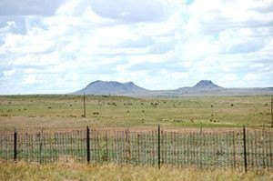
New Mexico Highway 406 now crosses McNees Crossing, the point where the trail forded the North Canadian River. Located about 3.8 miles southwest of the Oklahoma border in Union County, this rocky ford, still visible today, is named after Robert McNees, a young trader killed by Native Americans in 1828. The site also served as a popular campground; in 1831, a group of traders celebrated Independence Day here. From Clayton, the modern byway follows U.S. 56 westward, passing the Rabbit Ear Mountains, distinctive twin peaks that served as a crucial landmark for travelers on the trail. Alt Text: Rabbit Ear Mountains landmark along the Santa Fe Trail in New Mexico.
Point of Rocks, another significant landmark, lies north of U.S. 56, approximately 22 miles east of Springer in Colfax County. This location, once a favored campsite due to a nearby spring, bears a somber history. In 1849, the party of Santa Fe merchant J.W. White was attacked nearby, resulting in the deaths of eleven men whose graves are still present at the site. Today, Point of Rocks is part of a private ranch but is accessible to the public.
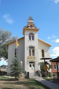 The Santa Fe Trail Museum in the old Colfax County Courthouse in Springer, New Mexico
The Rock Crossing of the Canadian River, also in Colfax County, was a site of strategic importance long before the Santa Fe Trail. Indigenous peoples used this natural stone ford, and later, it became a key crossing point for the Cimarron Route. The riverbed’s unique stone floor provided a firm footing for wagons, unlike the sandy riverbed upstream or the impassable canyon downstream. This crossing was often considered the unofficial entry point into Mexican territory, and Mexican troops were sometimes stationed here to escort traders towards Santa Fe. It was also a location prone to Native American raids on wagon caravans. The crossing is located on private land, about two miles south of US Highway 56. Alt Text: Santa Fe Trail Museum housed in historic Colfax County Courthouse, Springer, New Mexico.
Springer, situated six miles west of the Canadian River crossing, is home to the Santa Fe Trail Museum, housed within the impressive 1882 Colfax County Courthouse. From Springer, the byway follows the east frontage road of I-25 towards Wagon Mound, the final major landmark on this stretch of the Cimarron Route. In 1850, tragedy struck near Wagon Mound when a party of ten men accompanying an express mail wagon were killed by Jicarilla Apache.
The trail then progressed towards Watrous, where it converged with the Mountain Branch. Along the Cimarron Route, several trading ranches and stage stations provided essential services. These included the Samuel B. Watrous Ranch House and Store, the site of Barclay’s Fort north of Watrous, and the Sapello Stage Station, also known as Gregg Tavern Stage Station or Barlow & Sanderson Stage Station, in Watrous itself.
Raton Pass, New Mexico, presented a formidable obstacle to travelers on the Mountain Route.
The Mountain Route, entering New Mexico from Colorado, featured its own set of significant locations, including the Lucien Maxwell House site, Ocate Crossing, and Fort Union National Monument.
Crossing Raton Pass was the most arduous part of the Mountain Route journey. In 1865, Richens “Uncle Dick” Wootton capitalized on this challenge by establishing a toll road through the pass. He charged wagons $1.50, horses 25¢, and livestock 5¢ per head, while allowing Native Americans to use the road without charge. Today, Interstate 25 largely parallels this historic road.
From Raton Pass, the byway follows Moulton Street southeast to Second Street in Raton, originally known as Willow Springs. Willow Springs served as a crucial water stop for stagecoaches and a freight depot on the Santa Fe Trail. South of Raton, the Santa Fe Trail National Scenic Byway picks up on U.S. 64 and continues through Cimarron. Established around 1844, Cimarron became the headquarters for the vast 1.75-million-acre Maxwell Land Grant in 1857. Wagon trains entered Cimarron’s plaza from the east after crossing the Cimarron River. Lucien Maxwell also constructed the Aztec Mill in Cimarron, which still stands today as the Old Mill Museum on 17th Street, open during the summer months.
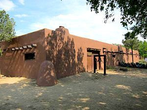 Kit Carson Museum, Rayado, New Mexico courtesy Wikipedia
From Cimarron, the trail continued to Rayado, located 12 miles to the south. Rayado originated as a Santa Fe Trail campsite established by Lucien Maxwell in 1848. It marked the point where the Mountain Route and two of its side trails converged. In the early 1850s, a military camp was established at Rayado to protect this section of the Mountain Route. Maxwell’s old residence has been restored and can be visited today. Alt Text: Kit Carson Museum in Rayado, New Mexico, historic site along the Santa Fe Trail.
Ocate Crossing in Mora County provided another essential watering point and campsite. This route saw significant use during and after the Civil War and is frequently mentioned in trail travelers’ accounts. General Stephen Watts Kearny’s Army of the West crossed here in 1846 and established a nearby camp.
Fort Union National Monument, also in Mora County, lies near the junction of the Cimarron and Mountain Routes. Fort Union served as a major military installation on the Santa Fe Trail from 1851 to 1891. For a period, it was the largest American military post in the Southwest, primarily established to safeguard the trail. The original fort structures deteriorated by the Civil War, prompting the construction of a new fortification. After the Civil War, a third Fort Union was built, encompassing a garrison and traditional post, a regional quartermaster depot, and an arsenal, all on the original fort site.
Between Watrous and Santa Fe, one of the most historically significant sites is Pecos National Historic Park in San Miguel County. This park encompasses the site of Pecos Pueblo, the easternmost pueblo visited by Francisco Coronado in 1541. While still inhabited when the Santa Fe Trail opened in 1821, Pecos Pueblo was abandoned around 1838. The deserted pueblo became a campsite for trail travelers and is frequently documented in their journals. Along this combined section of the trail, other notable locations include Las Vegas Plaza, Tecolote, San Miguel del Vado, Apache Canyon, Kearny Gap, and Glorieta Pass. Trading ranches such as Kozlowski’s Stage Station, Pigeon’s Ranch, and Johnson’s Ranch Site also dotted this part of the route.
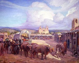 The Santa Fe Trail ends in Santa Fe, New Mexico
Ultimately, travelers on the Santa Fe Trail reached their destination: Santa Fe Plaza. Established around 1610 by Don Pedro de Peralta, the Plaza has been Santa Fe’s commercial, social, and political heart for centuries. During the Santa Fe Trail’s peak in the 19th century, the Plaza bustled with carts, goods, livestock, traders, and townspeople. Buildings in Pueblo, Spanish, and Territorial styles surround the Plaza, reflecting the city’s rich cultural heritage. One of the most prominent historic buildings is the Palace of the Governors. Constructed in 1610, it served as the seat of government in New Mexico under Spanish, Mexican, and American rule for 300 years. It is the oldest continuously used public building in the United States and is now part of the Museum of New Mexico. Alt Text: Santa Fe Plaza, the historic end point of the Santa Fe Trail in Santa Fe, New Mexico.
While the Santa Fe Trail’s extensive use diminished by 1880, its legacy, stories, and profound influence endure. For nearly 60 years, goods, ideas, and a vibrant exchange of cultures traversed this trail. This mixing of cultures and ideas forged a unique Southwestern identity that continues to resonate today.
© Kathy Weiser-Alexander/Legends of America, updated July 2024.
Also See:
People of the Santa Fe Trail
Santa Fe, New Mexico
Santa Fe Trail – Highway To the Southwest
Santa Fe Trail in New Mexico
Santa Fe Trail Photo Print Gallery
Sources: See Santa Fe Trail Site Map & Writing Credits