Hurricane Willa has rapidly intensified into a dangerous Category 5 hurricane in the Eastern Pacific Ocean and is currently on a path toward the western coast of Mexico. The storm is expected to make landfall on Tuesday along the border between the Mexican states of Nayarit and Sinaloa. This powerful hurricane is part of an unusually active Eastern Pacific hurricane season, raising concerns for significant impacts across Mexico.
Hurricane Willa’s Forecast and Intensity
Currently, Hurricane Willa is maintaining its strength as a Category 5 storm, posing a life-threatening risk. Forecasts indicate a high degree of confidence in the storm’s track, predicting landfall over Las Islas Marias late Tuesday and moving inland over west-central Mexico by early Wednesday morning. While Puerto Vallarta and Riviera Nayarit are expected to be slightly south of the storm’s direct path, and Mazatlan to the north, these population centers will still experience significant weather impacts.
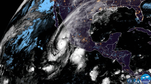 GOES East 17 satellite loop of Hurricane Willa.
GOES East 17 satellite imagery capturing the development of Hurricane Willa in the Eastern Pacific.
Meteorologists predict that Hurricane Willa will likely make landfall as a major hurricane, although some weakening is possible before reaching the coast. Factors influencing the storm’s intensity include favorable deep ocean heat and upper-level divergence, which support intensification. However, increasing wind shear along its projected path and a potential eyewall replacement cycle could limit further strengthening or even cause slight weakening just before landfall. An eyewall replacement can sometimes briefly reduce intensity but also expand the hurricane’s overall wind field, increasing the area of impact.
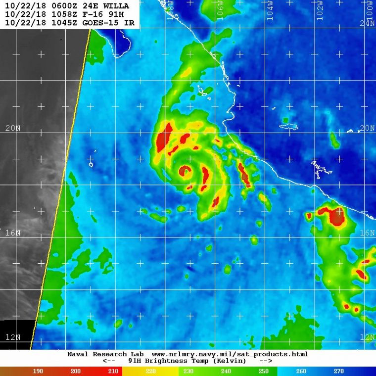 Microwave imagery of Hurricane Willa, showing a small compact eye, along with the beginnings of a secondary eyewall.
Microwave image illustrating the structure of Hurricane Willa, revealing a compact eye and the formation of a secondary eyewall.
Anticipated Impacts in Mexico from Hurricane Willa
Mexico is bracing for significant impacts as Hurricane Willa approaches. A dangerous storm surge is anticipated to inundate coastal areas, accompanied by large and destructive waves. The most severe storm surge and wave action are expected to occur to the right of the hurricane’s landfall point. Even if Willa weakens slightly before landfall, the potential for extensive structural and infrastructure damage remains high, particularly within the eyewall region where the strongest winds will be concentrated.
Rainfall is another major concern, with forecasts predicting accumulations of 5 to 10 inches along the coast, and potentially higher amounts as the storm moves inland over the mountainous states of Zacatecas and Durango. These heavy rains increase the risk of power outages, wind damage, flash flooding, and landslides, which are likely to extend well inland from the immediate landfall area. Residents in these regions should prepare for hazardous conditions.
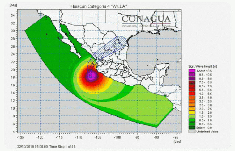 Significant wave height forecast for Hurricane Willa approaching Mexico.
Forecast depicting the significant wave heights expected as Hurricane Willa nears the Mexican coastline.
Potential Rainfall Impacts in the United States
After traversing Mexico, the remnants of Hurricane Willa are expected to move into central and southern Texas. This region has already experienced above-average rainfall and flooding. While the exact track and rainfall amounts are still somewhat uncertain, additional rainfall of 4 to 5 inches is possible in Texas. While this level of rainfall is unlikely to cause widespread urban flooding, it could exacerbate existing high river levels and lead to localized river flooding. Agricultural areas, particularly cotton crops, may also be vulnerable to these secondary impacts.
Hurricane Season Context and Historical Parallels
Hurricane Willa is notable for being a late-season Category 4 or 5 storm in the Eastern Pacific basin. Late-season storms in this region often follow a path recurving toward the Mexico coastline. This active 2018 hurricane season in the Eastern Pacific is statistically remarkable. Willa is the third Category 5 hurricane and the tenth major hurricane (Category 3 or higher) of the season. The Accumulated Cyclone Energy (ACE) for the 2018 season is significantly above average, exceeding even the very active 1992 season. This heightened activity is particularly noteworthy as it is occurring without the influence of El Niño conditions, which typically enhance hurricane activity in this basin.
Comparisons are being drawn between Hurricane Willa and Hurricane Patricia, another Category 5 hurricane that made landfall south of Puerto Vallarta in October 2015. Hurricane Patricia reached record-breaking intensity in the Western Hemisphere before weakening slightly to a strong Category 4 at landfall. While Patricia caused extensive damage in Jalisco, primarily to agriculture and infrastructure in a rural area, Hurricane Willa is forecast to make landfall further north, potentially impacting different regions of coastal Mexico. Authorities and residents are urged to monitor forecasts closely and take necessary precautions as Hurricane Willa approaches.