Introduction
Hurricane Beryl, a storm of unprecedented early-season intensity, marked a significant event in the 2024 Atlantic hurricane season. This cyclone defied historical norms, setting records for its early formation and strength. While its journey spanned thousands of miles and impacted multiple regions, a critical point in its path was its landfall in Mexico’s Yucatan Peninsula. This article delves into Hurricane Beryl’s impact on Mexico, providing a comprehensive analysis of its wind damage, insured losses, and the broader context of this extraordinary weather event. We draw upon expert insights and data from CoreLogic Hazard HQ Command Central™ and the National Hurricane Center (NHC) to offer a detailed understanding of Hurricane Beryl’s Mexican landfall and its place within the larger storm narrative.
Beryl’s Journey to Mexico: From Category 5 to Yucatan Peninsula
Hurricane Beryl’s origins were far east in the Atlantic Ocean, where it rapidly intensified, becoming the earliest Category 5 hurricane on record. Before reaching Mexico, Beryl had already made landfall as a devastating Category 4 hurricane over Grenada and subsequently impacted Jamaica and the Cayman Islands. Weakening slightly after these land interactions, Beryl still maintained significant strength as it approached the Yucatan Peninsula.
On the morning of July 5, 2024, Hurricane Beryl officially made its second landfall over the Yucatan Peninsula northeast of Tulum, Mexico. According to the NHC, this landfall occurred at 6:05 a.m. local time (11:05 a.m. UTC). At this point, Beryl was still a strong Category 2 hurricane, packing maximum sustained winds of 110 mph and a minimum central pressure of 975 millibars (mb).
Impact on Mexico’s Yucatan Peninsula: Wind and Insured Losses
Despite some weakening before landfall, Hurricane Beryl brought significant hurricane-force winds to the Yucatan Peninsula. Weather stations recorded substantial gusts and sustained winds, indicating a direct hit. A weather station at Xcaret Park in Cancun reported a maximum wind gust of 81 mph and sustained winds of 59 mph. Another station at Xel-Há Park, situated between Playa Del Carmen and Tulum, registered a minimum central pressure of 980.9 mb.
CoreLogic Hazard HQ Command Central™ provided estimates of the insurable losses resulting from Hurricane Beryl’s passage through Mexico. Their analysis indicated that total insurable losses in Mexico’s Yucatan Peninsula were expected to be less than $1 billion. These estimates encompass wind damage to various property types, including residential, commercial, industrial, and agricultural properties. The losses also account for damage to contents and business interruption. It is important to note that these figures represent insurable losses before the application of insurance terms like deductibles.
Contextualizing the Impact: Jamaica and the Cayman Islands
Before impacting Mexico, Hurricane Beryl brushed past Jamaica and the Cayman Islands. While these regions were affected, the most intense core of the storm largely spared densely populated areas like Kingston and Grand Cayman. This fortunate track mitigated potentially much higher insured losses in these Caribbean islands. CoreLogic estimates placed total insurable losses across Jamaica and the Cayman Islands between $400 million and $700 million.
Jon Schneyer, CoreLogic’s Director of Catastrophe Response, highlighted the near miss for Jamaica: “While it’s unfortunate that a part of Jamaica experienced the devastating winds of Hurricane Beryl, it is lucky the storm stayed just far enough south of Kingston and merely brushed against Jamaica, its strong winds avoiding the most populated areas. A more northward shift could have caused a stronger storm surge and wind event in the more developed areas of Kingston, like what happened in 1988 with Hurricane Gilbert.”
This comparison underscores how landfall location plays a crucial role in determining the extent of insured losses from hurricanes.
Beryl’s Meteorological Significance: A Record-Breaking Storm
Hurricane Beryl’s journey was notable not only for its impacts but also for its meteorological milestones. Dr. Howard Botts, Chief Scientist at CoreLogic, emphasized the storm’s unprecedented nature: “This is the sort of behavior we would expect to see in late August or early September during the peak of hurricane season. To see a major tropical cyclone east of the Caribbean in late June is almost unheard of. A Category 5 hurricane in early July has never been recorded.”
Beryl became the earliest Category 5 hurricane ever recorded in the Atlantic basin, surpassing the previous record held by Hurricane Emily in 2005. Its peak intensity of 165 mph also made it the strongest hurricane ever observed in July. These records are attributed to exceptionally warm sea surface temperatures and favorable atmospheric conditions in the Atlantic Ocean, signaling potentially increased hurricane activity in the 2024 season.
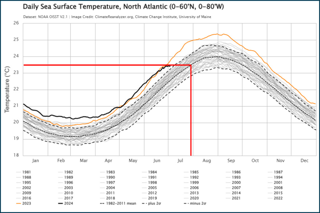 Figure 1: North Atlantic sea surface temperatures
From Yucatan to Texas: Beryl’s Continued Path and Texas Landfall
After traversing the Yucatan Peninsula, Hurricane Beryl weakened to a tropical storm as it moved into the western Caribbean Sea. However, forecasts indicated a potential for restrengthening as it moved northwest towards northeastern Mexico and southern Texas. This trajectory set the stage for Beryl’s final landfall in Texas.
On July 9, 2024, Hurricane Beryl made its final landfall over coastal Texas, after traveling over 4,000 miles from its origin. It came ashore over Matagorda County, approximately 90 miles from Houston, as a Category 1 hurricane with maximum sustained winds of 80 mph. Remarkably, even after landfall, weather stations in Houston recorded hurricane-force wind gusts, a phenomenon more typical of stronger hurricanes.
CoreLogic initially estimated total insured wind and storm surge losses in Texas to be between $700 million and $1.5 billion. However, as more data became available, this estimate was updated on July 11, 2024, to a range of $2.5 billion to $3.5 billion for insured wind losses in Texas alone. This significant upward revision highlights the complexities in initial loss estimations and the importance of ongoing data analysis in the aftermath of a hurricane.
 Figure 2: Hurricane Beryl wind history Source: National Hurricane Center, 2024
The updated Texas loss estimate included damage to residential, commercial, industrial, and agricultural properties, encompassing contents and business interruption, and demand surge. These figures assumed a typical residential policy deductible of 2%, acknowledging that variations in deductibles could influence the final insured loss totals.
Landfall Location Matters: Lessons from Beryl and Other Hurricanes
The impact of Hurricane Beryl, and hurricanes in general, is heavily dependent on the precise landfall location relative to population density and infrastructure. CoreLogic’s analysis emphasized this point by contrasting Beryl’s Texas landfall in a relatively less populated area like Matagorda Bay with the potential impact of a landfall in a major city like Corpus Christi or Galveston.
Jon Schneyer drew parallels with Hurricanes Idalia and Ian from previous years to illustrate this principle: “Hurricanes Idalia and Ian in 2023 and 2022 are good examples of why landfall location matters. Idalia, despite being a major hurricane at landfall, crossed the Florida coastline in the Big Bend region, a much less densely populated part of Florida. On the other hand, Hurricane Ian made landfall in southwest Florida over Cayo Costa near Fort Meyers… Landfall location matters.”
This understanding is crucial for risk assessment and insurance planning, as it highlights that storm intensity alone is not the sole determinant of insured losses.
Conclusion
Hurricane Beryl’s landfall in Mexico’s Yucatan Peninsula was a significant chapter in a historic storm event. While the insured losses in Mexico were estimated to be less than $1 billion, this landfall was part of a broader narrative of a record-breaking hurricane that traversed the Atlantic and impacted multiple regions. From its unprecedented early-season Category 5 status to its eventual landfall in Texas, Hurricane Beryl underscored the increasing complexities of hurricane risk and the importance of accurate, data-driven analysis for understanding and mitigating potential losses. CoreLogic Hazard HQ Command Central™ continues to monitor hurricane activity, providing crucial insights for the insurance industry and communities facing these powerful natural disasters.
References:
- National Hurricane Center (NHC) Reports and Archives
- CoreLogic Hazard HQ Command Central™ Data and Analysis
- CoreLogic Intelligence – Hurricane Risk Report