The western Gulf of Mexico is currently under scrutiny for potential tropical development as we approach next week. While rapid formation isn’t anticipated, the possibility of a slow-developing tropical system warrants attention, particularly for those monitoring rainfall forecasts across Texas, Louisiana, and Mexico. Although the Atlantic tropical wave seems less likely to develop imminently, the Caribbean remains an area to watch in the longer term.
For those along the Gulf Coast, the current weather pattern requires vigilance. Even without immediate signs of a robust tropical system, atmospheric conditions suggest a need for close monitoring. Current weather models indicate a subdued outlook for significant tropical development in the coming week. Instead, the primary concern for the Gulf Coast over the next week is substantial rainfall.
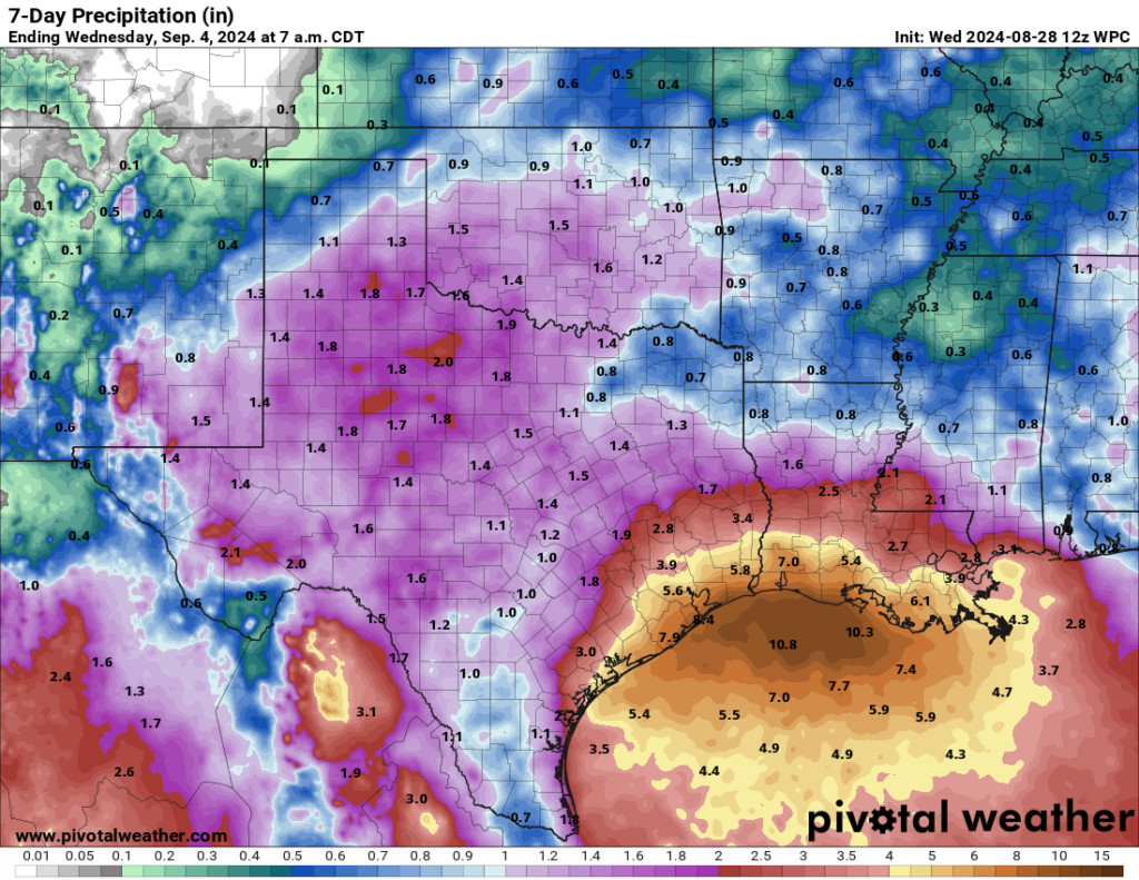 Rainfall forecast for the next week highlighting potential for 4 to 8 inches along the Gulf Coast from Southeast Texas to Louisiana.
Rainfall projections for the next week consistently point towards significant accumulation, potentially reaching 4 to 8 inches, especially along and south of Interstate 10 in Southeast Texas and Louisiana. The anticipated steady pace of this rainfall is expected to mitigate major flooding risks. However, the Gulf Coast’s susceptibility to flash and street flooding in such weather patterns means residents should remain prepared for localized flooding events.
Turning back to the potential for tropical development, satellite observations over the western Gulf reveal considerable thunderstorm activity.
These storms are currently linked to an upper-level low-pressure system, which is noteworthy because tropical systems typically originate at the surface. While upper-level lows are not conducive to immediate tropical storm formation, they can sometimes evolve and lead to surface low development. Should a surface low materialize, it could trigger a gradual tropical development process. This scenario could also alter rainfall distribution patterns in the coming week. Some weather models are indeed suggesting the formation of a surface low within the next five to six days.
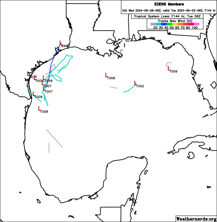 European ensemble model projection showing a minority of members indicating surface low development off the Texas coast during Labor Day weekend.
While not universally predicted, a number of European ensemble model runs, along with the ICON model, are indicating this possibility. The ICON model, despite its sometimes inconsistent reputation in tropical forecasting, is showing a relatively consistent signal for surface low formation in this instance. Even European model AI guidance is hinting at this potential development.
This model consensus suggests that the western Gulf of Mexico is an area to monitor closely for potential tropical development in the coming days. Importantly, current models do not project this potential system to strengthen into a hurricane. However, a slow-moving system situated off the Texas coast could still generate significant rainfall, potentially exceeding current forecasts. Weak steering winds in the western Gulf next week would contribute to the slow movement of any developing system. If a system remains offshore, the impact would be minimal. However, any northward or westward drift could pose a greater threat to parts of Texas, Louisiana, or Mexico.
In summary:
- Tropical development in the Gulf of Mexico is not guaranteed but remains a distinct possibility within the next five days, particularly off the Texas coast.
- Any tropical system that does form is expected to develop and move slowly.
- Rainfall forecasts for next week could fluctuate depending on the evolution of this potential system.
- Uncertainty persists, making continuous monitoring essential for the most up-to-date information.
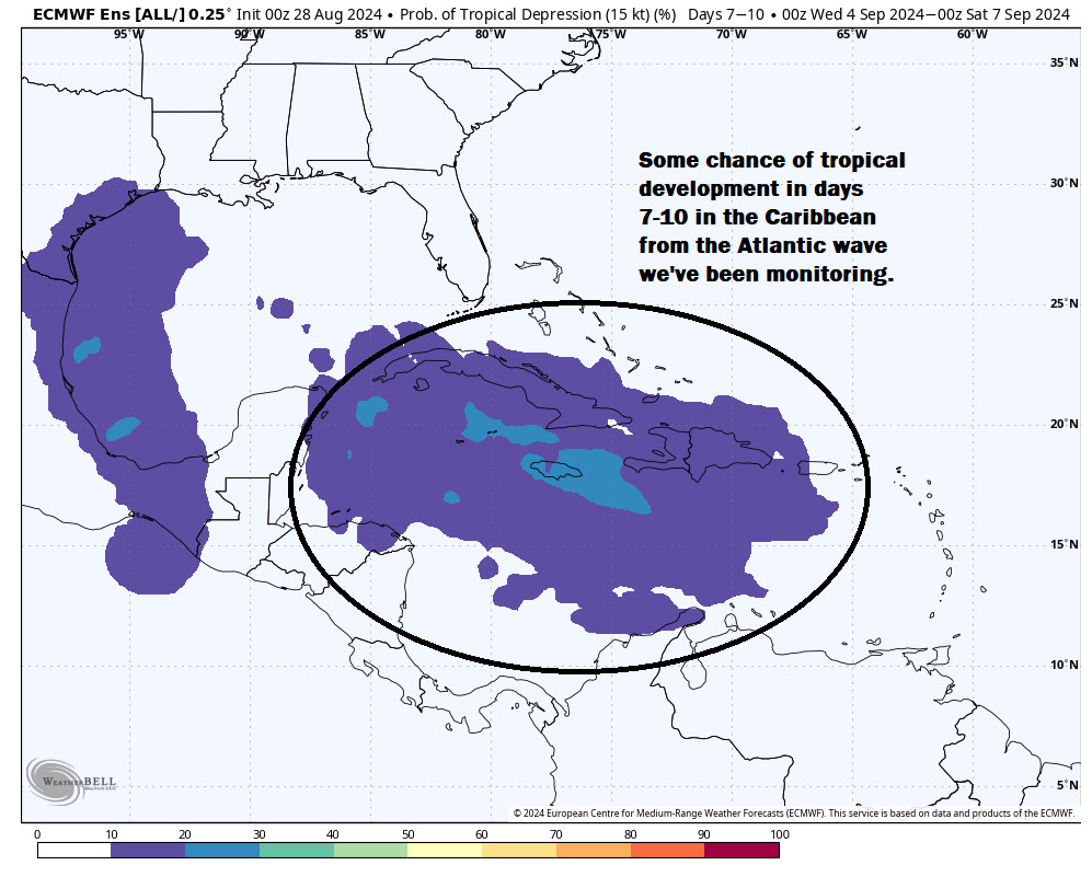
Focusing on the Atlantic, the tropical wave approaching the islands next week appears to have a reduced chance of immediate development. The National Hurricane Center still indicates a 20 percent chance, but model support has diminished somewhat. This suggests that any development in the Atlantic might be delayed until the system reaches the Caribbean. The ICON model loop supports this idea, placing the disturbance south of Hispaniola by mid-next week, indicating a potential for slower development.
 Projected path of Atlantic tropical wave moving into the Caribbean with potential for slow tropical development.
The likely trajectory for this Atlantic system now appears to be westward into the Caribbean, a shift from earlier predictions that suggested a path similar to Ernesto off the U.S. East Coast. It is anticipated to move towards the northwest Caribbean, influenced by high pressure to the east of the Bahamas. Beyond that point, the future path becomes less certain, potentially entering the eastern Gulf or approaching the Yucatan Peninsula. While immediate development is not expected, this Atlantic wave is a reminder to stay attentive as we enter the peak of hurricane season.
Looking further out in the Atlantic, models continue to indicate another tropical wave emerging off Africa. This system is currently projected to turn harmlessly northward in the eastern or central Atlantic. We will continue to monitor this wave for any changes in its projected path and development potential. The NHC is also tracking another area in the open Atlantic southeast of Bermuda with a very low chance of development, which is not expected to pose any threat.