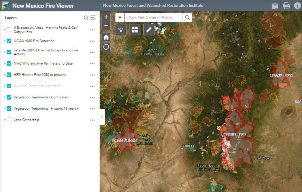
The New Mexico Fire Viewer is a valuable resource for tracking wildfires across the state. This free, interactive web map provides up-to-date information on active fires and historical burn scars, offering crucial insights into fire behavior and potential risks.
 The New Mexico Fire Viewer
Developed by the GIS Team, the New Mexico Fire Viewer integrates data from satellites and GIS layers to provide a comprehensive overview of New Mexico fires. Users can pinpoint active wildfire perimeters and hot spots, updated every few hours via satellite infrared imagery. Initially designed for monitoring the Hermit’s Peak and Calf Canyon fires near Las Vegas, NM, the viewer now encompasses all active fires within the state.
The map incorporates crucial data layers, including land ownership, soil burn severity maps, building footprints (sourced from Microsoft), and vegetation treatment data from the NMFWRI. This allows users to assess fire impacts on structures and landscapes. Historical burn scar data provides context and insights into long-term fire patterns.
Powered by ArcGIS Online and hosted by New Mexico Highlands University, the platform enables users to customize their view by toggling layers on and off. Zooming capabilities allow for detailed inspection of specific areas or a broader statewide perspective. Hot spot information refreshes automatically every four to eight hours, thanks to data streamed from NOAA satellites. Daily updates to fire boundary information come from the National Interagency Fire Center. Users are encouraged to refresh the map regularly for the most current information. To date, the web map has garnered over 305,000 views.
The NM Fire Viewer’s ability to consolidate fire data from various agencies, including the New Mexico State Forestry Division, tribes, BLM, USDA-Forest Service, and the New Mexico State Land Office, provides a comprehensive understanding of the fire situation.
The New Mexico Fire Viewer will continue to be a critical tool for tracking future Fires In New Mexico. Access the Fire Viewer at: https://arcg.is/TbCy. Additional resources, including the NM Vegetation Treatment Mapping project, are available at: https://nmfwri.org/gis-projects/nm- vegetation-treatment-mapping/